

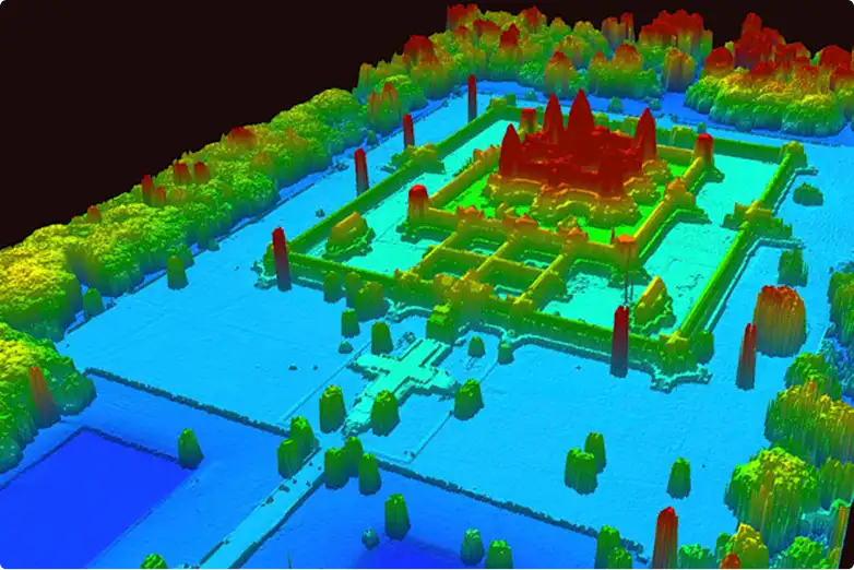
We have a saying at C-N-I Locates – “It’s a jungle out there.” In many ways, the concrete jungles we work in can be even more challenging than remote wilderness. While untouched areas may be difficult to access, urban environments are crowded with overlapping utilities, aging infrastructure, undocumented changes, and countless hidden obstacles beneath the surface.
Now, picture this – you are surrounded by towering trees and thick undergrowth. The canopy above you let’s only slivers of light pierce through and while you don’t see any movement around you, you can sense the entire forest being alive, breathing, growing, watching. And beneath all of it, another world. Completely invisible from above and often times forgotten and neglected. Ancient cities sprawling over hundreds of miles filled with artifacts, treasures and the remnants of civilizations that helped shape modern day humanity.
If you think about it, it’s not so different from Seattle, WA for example. A huge city with millions of people and cars zooming around. In a way, our cities and neighborhoods are also alive. Evolving and changing constantly. And underneath the pavement, a web of wires and pipes that are essentially the veins and neural pathways of our great cities. They are responsible for carrying the energy, water, gas, data (in the form of internet infrastructure) and much more, but similar to how the jungles swallow what is left unmanned, all that infrastructure is often forgotten because people rarely have to interact with it. Turn the water tap or the lights and they usually just work.
Us being a utility locating company, we deal with such things on a daily basis. CNI Locates is responsible for finding the “hidden treasures” under our roads and in turn assist construction and maintenance crews in staying safe and reducing costly delays.
In order to help you better understand how we do our work, we decided to do a multi-part series drawing parallels between how archeologists use LiDAR in order to uncover ancient civilizations and the way utility locating companies use GPR, Aerial Drone Imagery and more to achieve the same. So, strap in, because it’s a jungle out there!
What is LiDAR and How Does It Work?
Light Detection and Ranging – (for short LiDAR) is a technology that has fundamentally transformed our ability to visualize hidden landscapes. As Fisher and colleagues noted in their 2017 study published in Quaternary International, “It is a conundrum of the 21st Century that there is much left to discover and yet never before has our cultural and ecological patrimony been so threatened” (Fisher et al., 2017). This is especially true in tropical regions where heavy vegetation, inaccessibility, and rugged topography have historically hampered investigation.
In these areas filled with dangerous flora and fauna, snakes and spiders aren’t the only thing preventing archeologists from uncovering what’s underneath. It’s the terrain itself! Even equipped with state-of-the-art gear and having the will to go for days without seeing anything resembling civilization, a crew of scientists would need years to find anything worthwhile, let alone map it out. Most of the ruins of ancient cities are often buried under layers of undergrowth and dirt.
And that’s where LiDAR – a technology that operates on a relatively simple principle – comes in.
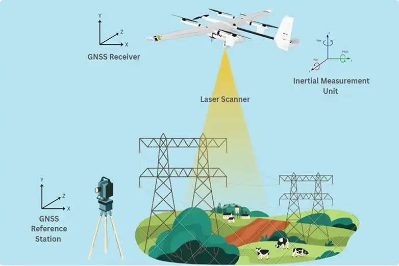
A specialized aircraft equipped with a laser scanner fires millions of pulses toward the ground and measures the time it takes for each pulse to return. Similar to how bats and marine animals use echo location to track their pray. In this case though, the purpose is not to lock-onto a moving pray. By calculating the travel time of the laser pulse hitting the surface and coming back up, the system creates a precise three-dimensional map of anything that it flies over. And here’s where the magic happens – because vegetation is partially transparent to these laser pulses, some energy penetrates through the canopy, reflects off the actual ground surface, and returns to the sensor.
Sophisticated filtering algorithms then remove the vegetation, revealing what archaeologists call a “bare earth” digital elevation model (DEM). As Hare and colleagues explained in their 2014 study of Mayapán, they used LiDAR at an extraordinary density of “40 laser points per square meter to generate a bare earth digital elevation model” (Hare et al., 2014). This density allowed them to see not just large pyramids, but individual rooms, benches, and stone property walls that had been hidden for centuries beneath the jungle’s canopy.
Now that you understand the principle behind LiDAR, let’s explore a couple of actual historical sites. The first one being:
Angamuco, Mexico
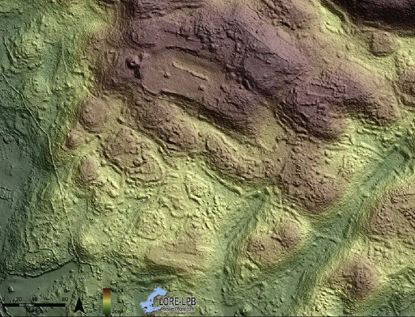
Prior to the LiDAR survey, archaeologists had limited understanding of pre-Columbian life in this region. What the lasers revealed was nothing short of revolutionary!
According to Fisher and colleagues, the LiDAR data showed that “large urban centers with complex spatial organization were present centuries prior to the formation of the Purépecha Empire” (Fisher et al., 2017). The settlement incorporated gardens and other landscape features within and around the urban area, demonstrating “a high degree of human environmental modification.” Most significantly, current models for the evolution of social complexity in the region could not account for Angamuco’s existence – meaning entire theories about how civilizations developed needed revision.
The city revealed itself through the laser data as a meticulously planned urban center with neighborhoods, roadways, and public spaces. What had been invisible beneath the forest canopy for nearly 500 years emerged as clearly as if the vegetation had been cleared by hand.
Very similar to how GPR and other utility locating technologies work to create a multi-dimensional representation of the subsurface infrastructure. But more on that later… Now, let’s head off to our next destination:
The Mosquitia Wilderness, Honduras
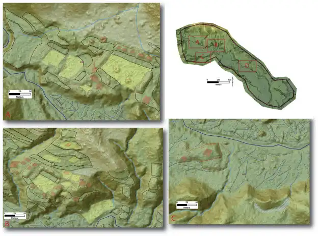
Perhaps even more dramatic was the LiDAR survey of a remote valley in the Mosquitia tropical wilderness of Honduras. This region, often called Central America’s “Little Amazon,” had seen little archaeological research precisely because of its inaccessibility and dense vegetation. It was considered a pristine wilderness, untouched by ancient humans.
The LiDAR data painted a completely different picture. As Fisher and colleagues reported, “though today the valley is a wilderness it was densely inhabited in the past” (Fisher et al., 2017). The population was organized into a three-tiered system composed of 19 settlements dominated by a city. Moreover, “this occupation was embedded within a human engineered landscape” – meaning the environment itself had been modified, terraced, and transformed by its ancient inhabitants.
What we thought was virgin forest was actually an abandoned and previously thriving garden, a landscape shaped by human hands and then reclaimed by nature.
And nature is often the reason why CNI Locates is on-site, helping out with the fight against the elements. Leaks, punctures and more can often happen due to corrosion, animal or seismological activity and if left unchecked, well, it probably won’t be completely buried underneath layers of plants, but it would surely cause a lot of problems for the people living and working in the area.
Speaking of “living and working” area let’s head back to:
Mayapán, Mexico
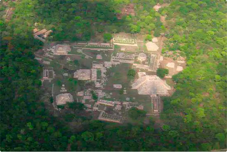
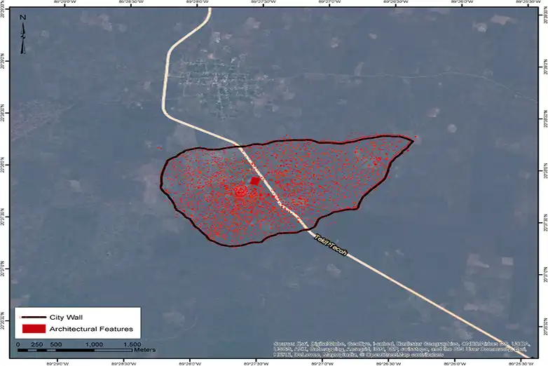
The Mayapán LiDAR Mapping Project, detailed by Hare and colleagues in 2014, demonstrates the extraordinary resolution achievable with modern LiDAR systems. Covering 40 square kilometers surrounding this ancient Maya city in Yucatan, Mexico, the project mapped out not just major monuments, but the subtle traces of daily life.
The results were remarkable. With the help of LiDAR, archeologists managed to document features that were completely missed out on when doing traditional “on foot with a compass and measuring tape” type of work. The Carnegie Institutes’ original map of Mayapán, created through decades of careful fieldwork, was found to contain considerable errors in the sizes, orientations, and relative positions of particular features.
Beyond the city walls, the LiDAR survey revealed something even more surprising: “an extensive modified landscape of terraformed residential hills, rejolladas (“solution sinkholes that form large, bowl-like areas with characteristics advantageous for horticulture” (Maia Dedrick et al., 2020)) and dense settlement dating from Preclassic through Classic Periods.” The region had been continuously occupied and modified for over 2,000 years, with each generation building upon the work of previous inhabitants.
The Challenge of “Sensationalism” – Should scientists “clickbait”?
It’s important to acknowledge, as Kathryn Reese-Taylor does in her 2025 review, that the popular presentation of LiDAR discoveries often veers into sensationalism. She examines how scientific publications become transformed in news media, with headlines touting “lost cities” and “mind-blowing” discoveries (Reese-Taylor, 2025). We are also a tad guilty of that. Our title was definitely “clickbaity” but we do at least hope you may have learned something reading through these blogs. After all, the purpose of them is to educate the public and not just push our services.
This narrative, Kathryn argues, “usually ignores existing knowledge, especially that of Indigenous local communities and archaeologists.” The technology reveals what was always there, known to local populations even if undocumented by science. This distinction matters. It does not diminish the technological achievement, but rather properly contextualizes it and raises a question about indigenous cultures and how often their voices are left unheard or misunderstood.
In a way, it is similar to what utility locating companies also do. We don’t just rely on our technological tools. Depending on the project, we might also cross-reference with existing infrastructure maps. In fact, the services of CNI Locates are also often used for adding to that body of knowledge.
Seeing Through
What unites these archeological studies is a common thread: the ability to take a peek beneath the surface and reveal what lies under. Whether it is the tropical forest canopy in Honduras, the dense scrub in Mexico, or a millennium of soil accumulation, LiDAR cuts through to reveal signs of human activity dating back thousands of years ago.
As Fisher and his colleagues concluded, “It has become clear that tropical forest ecosystems in the Americas were largely anthropomorphized at the time of European contact and that what we often think of today as tropical wilderness are in fact abandoned gardens” (Fisher et al., 2017). The “pristine” wilderness is a myth; everywhere humans have lived, they have left their mark. LiDAR simply allows us to read it more clearly.
In the next part of this fascinating exploration, we’ll be discussing how deep learning neural networks are helping scientists make sense of the raw data and much, much more.
In the meantime, if you are looking for a Utility Locating company that operates in Washington state, make sure to give CNI Locates a call at 877-826-1177.
And if you want to read one of these future articles here’s a full list:
Part 1: How Archeologists Used LiDAR to Uncover Ancient Mysteries Hidden Beneath the Surface
Part 2: How LiDAR is Transforming Archeology with the Help of Deep Learning
Part 3: Beyond Detection: Understanding Urban Organization
Part 4: The Hidden World Beneath Our Feet – Utility Locating in Washington State
