

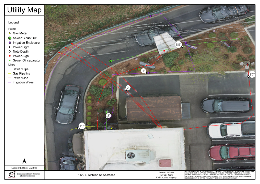
Subsurface Utility Engineering (SUE) refers to a structured approach used to identify, evaluate, and document underground utilities before excavation or construction begins. In Washington State, where infrastructure networks can be complex and densely installed, understanding subsurface conditions is critical for safe planning and execution. While public utility locates are initiated through 811 as required under RCW 19.122, those locates may not include privately owned infrastructure, such as building service lines or private sewer laterals. As a result, additional investigation is often required to improve subsurface visibility. Services such as utility mapping services in Washington are commonly used to document located utilities and support informed decision-making during project planning.
What Subsurface Utility Engineering (SUE) Involves
SUE is not a single service but a coordinated process that combines field investigation, data collection, and interpretation to better understand underground conditions. It is typically used during pre-construction planning to reduce uncertainty and support safer excavation practices.
The process may include:
- Reviewing available utility records and as-built drawings
- Conducting site inspections to identify accessible utility features
- Performing field locating using appropriate detection methods
- Verifying utility paths and marking them on the ground
- Collecting geospatial data where mapping is required
SUE helps organize subsurface information into a usable format, but results depend on site conditions, available records, and the limitations of detection technologies.
What 811 Covers and What It May Not
In Washington, contacting 811 before excavation is a legal requirement under RCW 19.122. This process helps identify publicly owned utilities such as main electrical, gas, and communication lines. However, it is important to understand that 811 locates may not include privately owned infrastructure.
Examples of utilities that may not be included:
- Private electrical feeds from the meter to structures
- Irrigation systems and landscape utilities
- Private water service lines
- Sewer laterals connecting buildings to municipal systems
Because of this distinction, property owners and contractors may need to verify whether utilities are public or private when planning work. In many cases, subsurface utility mapping in Washington is used to document both publicly marked and privately located utilities for a more complete understanding of the site.
Why Private Utility Locating Is Often Required
Private utility locating plays a key role in supporting SUE processes, especially when project areas include infrastructure not covered by public utility locates. Private locating services focus on identifying subsurface utilities that are not part of the 811 system.
This may include:
- Locating non-conductive utilities, such as plastic pipes
- Identifying undocumented or abandoned lines
- Verifying utility paths within private property boundaries
- Supporting excavation planning in complex environments
A qualified utilities locator may use a combination of technologies to improve visibility, depending on site conditions and access to utility features.
Technologies Used to Support Subsurface Investigations
SUE relies on multiple detection methods to gather subsurface information. No single technology can identify every utility or condition in all environments, which is why technicians often combine several approaches.
Common technologies include:
- Electromagnetic locating (EM) for conductive utilities such as electrical and metallic lines
- Ground Penetrating Radar (GPR) for detecting visible subsurface anomalies and non-conductive utilities
- Magnetic detection for locating ferrous objects such as valve boxes and buried markers
- Acoustic pipe detection for tracing pressurized water lines
- Video pipe inspections for internal pipe assessment and sonde tracking
- Utility mapping tools such as GNSS, RTK, or photogrammetry for recording utility locations
The effectiveness of these methods depends on factors such as soil composition, utility material, depth, congestion, and site accessibility. For this reason, combining methods is often necessary to improve confidence in findings. These technologies are frequently integrated into utility mapping services in Washington to support accurate documentation of field data.
Understanding Service Limitations in SUE
While SUE can significantly improve awareness of underground conditions, it is important to recognize that all subsurface investigation methods have service limitations. These limitations may be influenced by:
- Environmental conditions such as soil type and moisture content
- Utility depth and installation methods
- Interference from nearby infrastructure
- Limited access to utility connection points
- Signal distortion or weak signal return
Depth estimates may be provided when conditions allow, but they are considered approximate and may vary based on site-specific factors. As a result, findings from subsurface utility mapping in Washington should be used alongside engineering plans, site records, and field verification when making excavation decisions.
Conclusion
Subsurface Utility Engineering plays an important role in improving visibility of underground infrastructure before excavation begins. By combining multiple detection methods, reviewing available records, and documenting findings, SUE helps support safer planning and reduces the likelihood of unexpected utility conflicts. However, it is important to understand the distinction between public utility locates through 811 and privately owned infrastructure that may require additional investigation.
Recognizing service limitations and verifying findings through multiple approaches can help improve project awareness. For projects requiring detailed subsurface insight, C-N-I Locates Ltd. support contractors, engineers, and property owners by delivering reliable field data while maintaining a strong focus on safety and compliance.
