

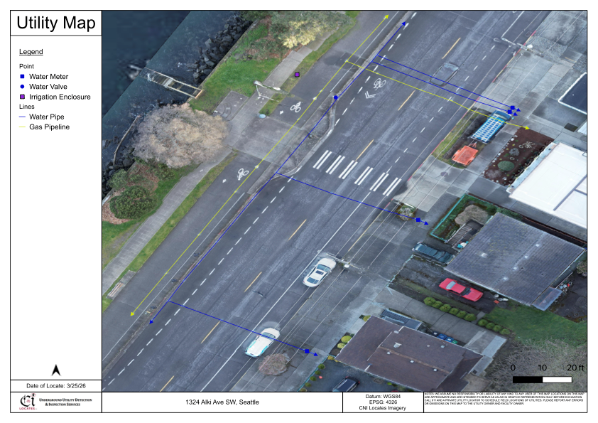
Understanding what lies beneath the ground is a critical part of safe excavation, construction planning, and infrastructure management. In Washington State, professionals rely on a combination of utility locating practices to improve subsurface visibility before any digging begins. While surface markings are commonly seen on job sites, they are only one part of a broader process. Many projects also require digital records that can be referenced long after markings have faded. This is where utility mapping services in Washington become relevant, helping document utility locations in a more permanent and structured format. It is also important to remember that Washington State law requires contacting 811 before excavation to identify public utilities, though private utilities may require additional investigation.
What Utility Marking Involves
Utility marking is the process of identifying and marking the approximate location of underground utilities on the ground surface. These markings are typically applied using paint, flags, or other visible indicators following standardized color codes.
Technicians perform marking after using detection methods such as electromagnetic locating or other applicable tools to trace utility paths. The purpose is to provide a visual reference for contractors and equipment operators before excavation begins.
However, surface markings have limitations:
- They are temporary and may fade over time
- Environmental conditions can affect visibility
- They may not represent all subsurface utilities
- Access constraints can impact detection
Because of these factors, marking is best understood as a short-term communication tool rather than a permanent record of underground infrastructure.
What Utility Mapping Involves
Utility mapping goes beyond surface markings by capturing the location of detected utilities in a digital format. This process involves recording spatial data using technologies such as GNSS, RTK systems, or aerial photogrammetry, depending on project requirements and site conditions.
Professionals performing mapping underground utilities in Washington convert field markings into geospatial data that can be used for planning, documentation, and long-term asset management. Unlike temporary markings, mapping creates a structured dataset that can be referenced after fieldwork is complete.
Key aspects of utility mapping include:
- Recording utility positions as coordinate-based data
- Capturing utility crossings, connections, and appurtenances
- Generating deliverables such as PDF maps, CAD files, or GIS-compatible formats
- Supporting future excavation, design, and infrastructure planning
It is important to note that mapping accuracy depends on factors such as satellite coverage, equipment type, and site conditions.
Key Differences Between Marking and Mapping
Although marking and mapping are often used together, they serve different purposes within a project workflow.
Utility marking:
- Provides immediate, on-site visual guidance
- Supports excavation safety in the short term
- Relies on surface indicators that may degrade Utility mapping:
- Creates a digital record of utility locations
- Supports long-term planning and documentation
- Can be integrated into design and asset management systems
While marking helps crews avoid utilities during active work, mapping helps organizations maintain a record of subsurface infrastructure for future use. Both processes depend on the quality of initial detection and are influenced by site-specific conditions.
Why Both Processes Are Often Used Together
In many projects, marking and mapping are not separate decisions but part of a combined workflow. Technicians typically perform utility locating first, apply surface markings, and then proceed with mapping if digital records are required.
This is where subsurface utility mapping in Washington becomes particularly valuable. By capturing the marked utilities into a digital format, project teams gain both immediate visibility and long-term documentation.
Multiple technologies may be used together during this process, including:
- Electromagnetic locating for conductive utilities
- Ground Penetrating Radar (GPR) for subsurface imaging
- Magnetic detection for ferrous components
- Camera inspections or sondes for non-conductive lines
Each method has operational limitations depending on factors such as soil conditions, utility material, depth, and accessibility. For this reason, technicians may combine different tools to improve overall visibility and confirm findings.
Limitations and Considerations
Both marking and mapping are subject to service limitations that must be understood before relying on the results.
Important considerations include:
- Not all utilities may be detectable under all conditions
- Depth estimates are approximate and may vary
- Congested underground environments can affect signal clarity
- Non-conductive utilities may require additional detection methods
- Access to utility connection points can impact results
Additionally, while 811 services help identify public utilities, private utilities such as irrigation lines, private sewer laterals, or building service connections may not be included. Property owners and contractors should verify whether additional locating services are required before excavation.
Conclusion
Utility marking and mapping serve different but complementary roles in subsurface investigations. Marking provides immediate visual guidance on-site, while mapping creates a lasting digital record that supports planning and documentation. Both processes rely on accurate detection methods and are influenced by real-world site conditions and service limitations. Understanding these differences helps contractors, engineers, and property owners make informed decisions before beginning excavation work. When combined effectively, these approaches improve overall awareness of underground infrastructure and support safer project execution. For projects requiring both surface visibility and longterm data, C-N-I Locates Ltd. provides services that align with these objectives while maintaining a strong focus on accuracy, safety, and professional standards.
