

Construction projects often involve significant planning before excavation, drilling, trenching, or site development begins. One of the most important components of that planning process is understanding what may exist below the surface. Unknown utilities, abandoned infrastructure, and incomplete records can create operational challenges that affect schedules, budgets, and site safety. As a result, many project teams incorporate underground utility locating into pre-construction planning to gather information about subsurface conditions before work starts.
Utility-related risks are inherent in commercial, industrial, and infrastructure projects of all sizes. The early availability of utility information provides contractors, engineers, facility managers, and property owners with the opportunity to make better decisions in the planning and design phases of the project.
Why Utility Risk Assessment Matters Before Construction
Subsurface conditions are not always fully documented. Utility records may be outdated, incomplete, or unavailable, particularly on older properties where modifications have occurred over time. Even when drawings exist, field conditions can differ from historical documentation.
A structured utility risk assessment helps project teams evaluate:
- Existing utility infrastructure that may affect construction activities
- Areas requiring additional investigation before excavation
- Potential conflicts between planned work and existing utilities
- Access considerations for construction equipment
- Locations where supplemental detection methods may be beneficial
Gathering this information before construction activities begin can help support more effective project coordination.
The Role of Utility Locating in Pre-Construction Planning
Pre-construction utility investigations often begin with a review of available records, utility plans, and project documentation. After reviewing available information, utility locating professionals perform a site assessment to identify potential utility access points and evaluate site conditions.
Electromagnetic utility locating is commonly used to identify conductive underground infrastructure. During this process, technicians may use receivers and transmitters to detect signals on metallic utilities. However, not all utilities are conductive or accessible for signal application.
Because site conditions vary, multiple technologies may be used during an investigation. Ground Penetrating Radar (GPR) can provide additional subsurface imaging that may assist in identifying nonconductive utilities, unknown underground features, or other subsurface anomalies. Combining technologies allows project teams to collect additional information when conditions warrant further evaluation.
Supporting Construction Decisions Through Utility Mapping
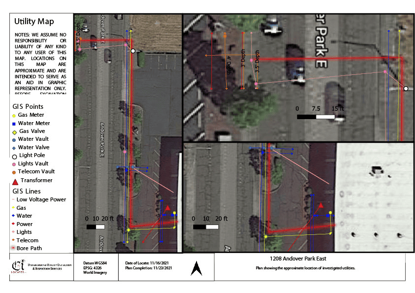
Once utilities have been identified, collected field information may be organized into mapping deliverables that support project planning activities. Depending on project requirements, utility data can be documented using GNSS or RTK-based mapping methods.
Many projects use subsurface utility mapping in Washington to better understand utility corridors, utility congestion, and potential construction conflicts before mobilization. Utility mapping can provide valuable documentation for planning discussions, design reviews, and field coordination efforts.
Mapping accuracy depends on methodology, site access, satellite coverage, environmental conditions, and other operational factors. For this reason, utility mapping results should always be reviewed within the context of project requirements and field conditions.
Understanding Detection and Operational Limitations
No utility locating technology is effective under all site conditions. Utility detection capabilities may be influenced by environmental factors, utility characteristics, site accessibility, interference, and available utility access points.
Examples of operational limitations include:
- Restricted access to utility connection points
- Congested underground environments
- Soil conditions that affect signal transmission
- Site features that influence GPR performance
- Incomplete utility records
For this reason, utility investigations often involve evaluating multiple detection methods rather than relying on a single technology.
Selecting the Right Utility Locating Provider
When evaluating a locating company, project teams often look for providers that can support utility locating, utility mapping, subsurface imaging, and utility documentation services. A structured workflow that includes site review, utility detection, documentation, and discussion of operational limitations can help support informed construction planning.
Early utility investigations are particularly valuable on sites with limited records, redevelopment projects, utility congestion, or planned excavation activities. The information collected during these investigations can assist project teams as they prepare for construction operations.
Conclusion
Successful pre-construction planning depends on understanding existing site conditions before excavation begins. Services such as underground utility locating, utility documentation, and subsurface utility mapping can provide important information that supports planning and risk evaluation efforts. When project teams require a professional locating company in Washington, the utility detection, mapping, and inspection services provided by C-N-I Locates Ltd. can help support informed decision-making throughout the pre-construction process.
