Benefits of Utility Mapping and Why It Is Important?
Utility mapping helps reduce accidents, budget overruns, costly rerouting, damaged reputations, injuries, project downtime, and project durations. Before performing subsurface work, it is tremendously valuable to have sophisticated information about utilities and features underground so you can avoid them and protect the integrity of the work area. Utility mapping is the process of identifying and documenting where underground utilities and features are located with sophisticated GPS, GNSS, or RTK receivers and putting that up to date information on a site map to reference during construction, engineering, environmental work, future utility locating services, subsurface work, surveying, etc.
CNI Locates technicians also have the ability to include aerial drone imagery with our utility mapping services. CNI Locates offers 3 different types of aerial drone imagery services.
- Aerial Drone Imagery- Is the capture of still images and video by a remotely operated or autonomous unmanned aerial vehicle (UAV), also known as an unmanned aircraft system (UAS) or, more commonly, as a drone. This service helps provide real time aerial pictures/videos of the work area so clients can see the site conditions upon the completion of the site.
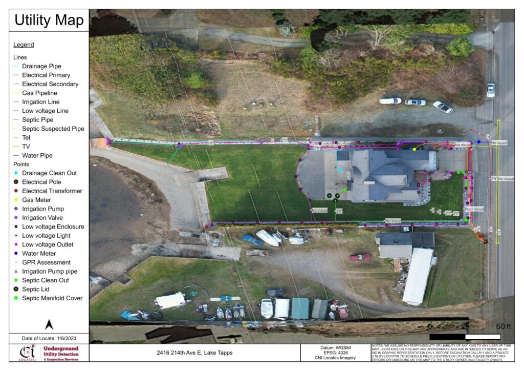
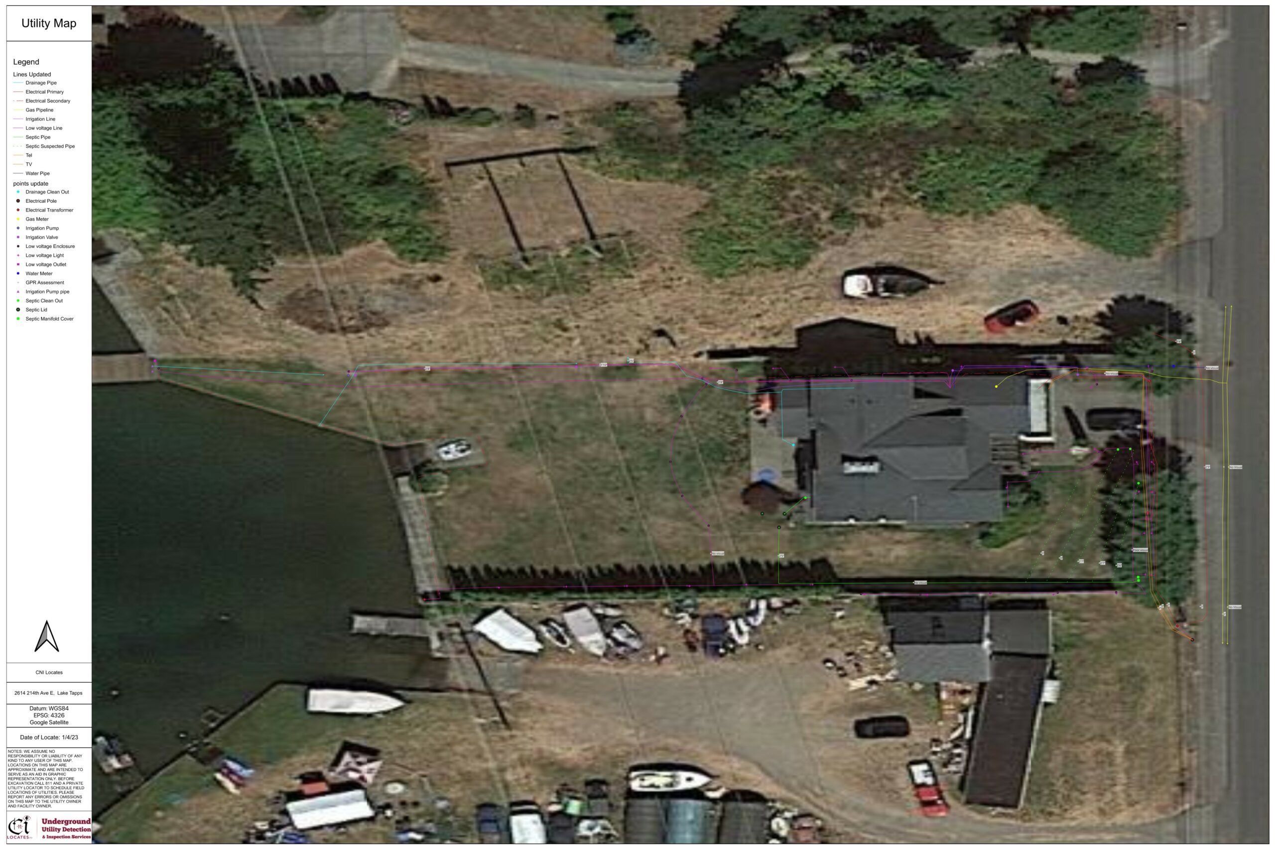
- Orthomosaic Photogrammetry- Is the output from a process where a number of overlapping photos from a drone are stitched together with distortions removed to create a complete and continuous image representation or map of a portion of the earth. This service helps display utility locations and depth assessments on real time high definition aerial images overlayed onto a map of the earth so you will have a high quality up to date site map instead of an antiquated low quality google earth map.
- 3D Photogrammetry- Is a technique for obtaining reliable data from real-world objects in their natural state by creating 3D models from photographs. 2D and 3D data is extracted from an image and with the use of overlapping photos of the object, building, terrain, etc. the images are converted into a 3D digital model. This service is useful if you want a real time 3d model of your site, if your site does not have a 3d image available on google earth, etc.
CNI Locates technicians provide reliable utility mapping services that help compliment all of the other underground utility detection & inspection services we have to offer. Our other services include Design Survey Locating, Electrical Fault Detection, Ground Penetrating Radar, Leak Detection, Magnetic Detection, Metallic Line Detection, Non-Metallic Line Detection, Plastic Water Pipe Detection, Public and Private Utility Locates, Sewer Crawler Inspections, Sophisticated Reports, Structural & Concrete Imaging, Utility Mapping, Video Push Camera Inspections, and much more in all of Oregon and Washington State.
Why Is It Important to Get Utility Mapping Services?
Below are some of the most common reasons why up to date utility mapping is important.
- To get a summary of the underground utilities and features in the work area before performing engineering, preliminary studies, planning in the early phase of subsurface work, future development, etc.
- To identify the depth, diameter, and path of the subsurface utilities and features in the work area (e.g., power, phone, tv, water, gas, sewer, drainage, lighting, irrigation, septic systems, underground storage tanks, graves, voids, and much more)
- For getting information about utilities and features on a map to reference during any subsurface work for the purposes of laying utilities or the relocation of them.
- To have up to date information about utilities and features on the property.
- To reference where previous leaks, faults, utility damages, voids, etc. have occurred on a property so you can monitor their locations.
Key Benefits of Utility Mapping Services Offered by CNI Locates
Property owners cannot rely on old maps since they can provide incomplete and inaccurate information about the location of the underground utilities. Therefore, they may seek services from a trustworthy utility locate company like CNI Locates to perform up to date subsurface utility mapping services. Below we have listed some of the key benefits of getting utility mapping services for your project.
- Access to Real-Time Data
Our utility mapping services use real-time data to give clients up to date information about their property. This service can also help you track the progress of your projects and any conflicts that could occur during them.
- Enhances Responsiveness
Utility mapping complements our other underground utility locating servicesand helps share real-time information between our technicians and our clients before performing any subsurface work or preliminary studies. It also helps reduce paperwork enabling you to have an improved and quicker decision-making process.
- Saves Money
Utility mapping services ensure work efficiency and safety and therefore results in cost reduction. It further helps to alleviate the need to develop prints, manual report preparation, paper maps to plot routes, and much more.
- Increases Workflow Efficiencies
Utility mapping services help increase workflow efficiencies by providing an up to date site map for clients to reference during subsurface work. It is common for marks to get removed, covered, or faded from construction, weather, traffic, time, etc. during a project. Utility mapping can assist clients to identify if utilities need to be relocated during the duration of a project, so you can avoid them.
- Improves Communication
Communication is important between our clients and technicians on projects (small or large). When it comes to remembering where subsurface utilities are located, human memory may not be enough. CNI Locates technicians can increase the quality of your communication and safety by providing precise and understandable markings, a field sketch, or map overlay of your project.
Get Utility Mapping Services Before You Perform Subsurface Work!
Subsurface utilities and features are constantly being damaged, installed, replaced, removed, upgraded, etc. Private utility locate companies like CNI Locates help you plan and design for these types of scenarios preventing unnecessary expenditures, damages, delays, and injuries. Let us help you keep your project on time, safe, and cost effective. CNI Locates has been Oregon and Washington’s leader in subsurface utility detection and inspection services for 20+ years. We have field offices in Everett, WA, Renton, WA, Seattle, WA, Tacoma, WA, Eugene, OR, and Portland, OR. Contact CNI Locates at (877) 826-1177 or email [email protected] to schedule a service within 24 hours’ notice, Monday-Friday.