

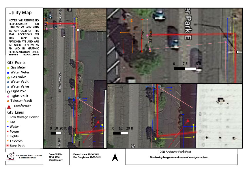
Construction, excavation, and infrastructure projects often involve working around buried utilities that may not be visible from the surface. Water lines, electrical conduits, communication lines, sewer pipes, and gas utilities can create operational challenges when their locations are undocumented, outdated, or difficult to verify in the field. This is one reason many contractors, municipalities, engineers, and property owners rely on underground utility mapping to support project planning and field coordination.
Utility mapping combines field locating methods with geospatial data collection to document the approximate location of subsurface infrastructure. Depending on project requirements, technicians may use GPS/GNSS data collection, RTK mapping, or orthomosaic photogrammetry to capture utility information and convert it into digital deliverables.
In Washington construction environments, utility mapping is frequently used to support excavation planning, infrastructure documentation, utility coordination, and long-term asset management.
Supporting Safer Excavation Planning
One of the primary benefits of mapping underground utilities is improved visibility into buried infrastructure before excavation activities begin. During construction planning, undocumented private utilities or abandoned utility corridors may create uncertainty for contractors and project managers.
A typical utility mapping workflow begins with utility locating services performed in the field. Technicians review available as-built drawings, utility records, and site conditions before tracing conductible utilities using electromagnetic locating equipment such as the Vivax vLoc3 or Radio Detection RD8200 receivers. Passive frequency sweeps and induction locating methods may also be performed to identify conductive utilities that cannot be directly connected to.
If site conditions limit electromagnetic locating, supplemental technologies may be recommended depending on utility type, accessibility, and client approval. These methods may include:
- Ground Penetrating Radar (GPR)
- Acoustic pipe detection
- Magnetic detection
- Traceable sondes or inserts
- Video camera pipe inspections
Once utilities are identified and surface markings are verified, technicians can begin collecting geospatial field data for mapping deliverables.
Because field conditions vary significantly between sites, utility mapping data should always be reviewed alongside excavation practices, project records, and site observations.
Improved Infrastructure Documentation
Many older properties and facilities contain buried infrastructure that has changed over time due to renovations, repairs, or utility upgrades. Existing records may not fully reflect current field conditions, particularly for private utilities.
This is where utility mapping services in Washington can provide valuable project documentation. Utility mapping allows located utility paths, valves, meters, vaults, hydrants, conduits, and other appurtenances to be digitally recorded using GNSS or RTK equipment such as the Trimble DA2 or Juniper Geode.
Depending on the requested deliverables, mapping data may be provided in formats such as:
- PDF utility maps
- KMZ files for Google Earth
- CSV coordinate files
- GIS-compatible data
- CAD deliverables
These records may assist with:
- Construction planning
- Utility inventories
- Facility management
- Future maintenance coordination
- Infrastructure upgrades
- Site redevelopment planning
Mapping accuracy depends on several variables, including satellite coverage, vegetation, surrounding structures, environmental interference, and the data collection method selected for the project.
Combining Multiple Detection Methods
No single locating technology can identify every buried utility or subsurface condition in all environments. Soil composition, utility material, congestion, accessibility, and depth can all influence field interpretation.
Because of this, underground utility mapping projects often involve multiple service applications working together.
For example:
- Electromagnetic locating may be used to trace conductive electrical or gas utilities.
- GPR may assist with identifying visible subsurface anomalies or non-conductive utilities.
- Acoustic pipe detection may assist with tracing pressurized non-metallic water services.
- Video camera inspections may assist with locating sewer or drain lines using traceable sondes.
- Magnetic detection may assist with locating buried ferrous infrastructure such as valve boxes or tracer wires.
Technicians evaluate field conditions throughout the project and discuss operational limitations with the client before additional methods are applied.
This layered approach helps support better field interpretation while recognizing that subsurface conditions can vary significantly across different project sites.
Utility Mapping for Large Project Areas
Large commercial developments, municipal projects, industrial facilities, and transportation corridors often require broader site visibility than traditional surface markings alone can provide.
In these environments, mapping underground utilities using orthomosaic photogrammetry may support project coordination across larger areas. Orthomosaic mapping uses overlapping aerial drone imagery captured with equipment such as the DJI Mavic 3 Pro to generate a high-resolution aerial image of the site.
Located utilities can then be digitally overlaid onto the aerial imagery, providing a visual reference for construction planning and utility coordination.
Orthomosaic mapping is commonly used for:
- Infrastructure planning
- Construction progress documentation
- Large utility corridor mapping
- Site redevelopment projects
- Asset management records
Environmental conditions, vegetation coverage, weather, and site accessibility may affect aerial imagery collection and mapping visibility.
Understanding Service Limitations
Like all subsurface investigation methods, utility mapping has operational limitations. Utility maps represent field interpretations based on detectable signals, site accessibility, and observable conditions at the time of service.
Several factors may affect mapping visibility and data collection, including:
- Congested utility corridors
- Non-conductive utilities
- Signal interference
- Limited access points
- Surface obstructions
- Soil conditions
- Depth variability
- Environmental interference
- Incomplete historical records
Depth readings are approximate and may vary depending on utility material, signal distortion, soil composition, and site conditions.
Additionally, utility mapping does not replace the requirement to contact 811 prior to excavation in accordance with RCW 19.122. Public utility locates requested through the 811 processes may not include private utility infrastructure, which may require private utility locating services depending on the project scope.
Conclusion
As construction and infrastructure projects continue to become more complex, digital utility documentation plays an increasingly important role in planning and field coordination. By combining locating technologies, geospatial data collection, and structured field workflows, utility mapping can assist contractors, engineers, and property owners with documenting buried infrastructure and supporting excavation planning activities.
For organizations seeking professional utility mapping services, underground utility mapping, or assistance with mapping underground utilities, C-N-I Locates Ltd. provides utility locating and mapping services that align with real-world field conditions, operational limitations, and project-specific requirements.
